
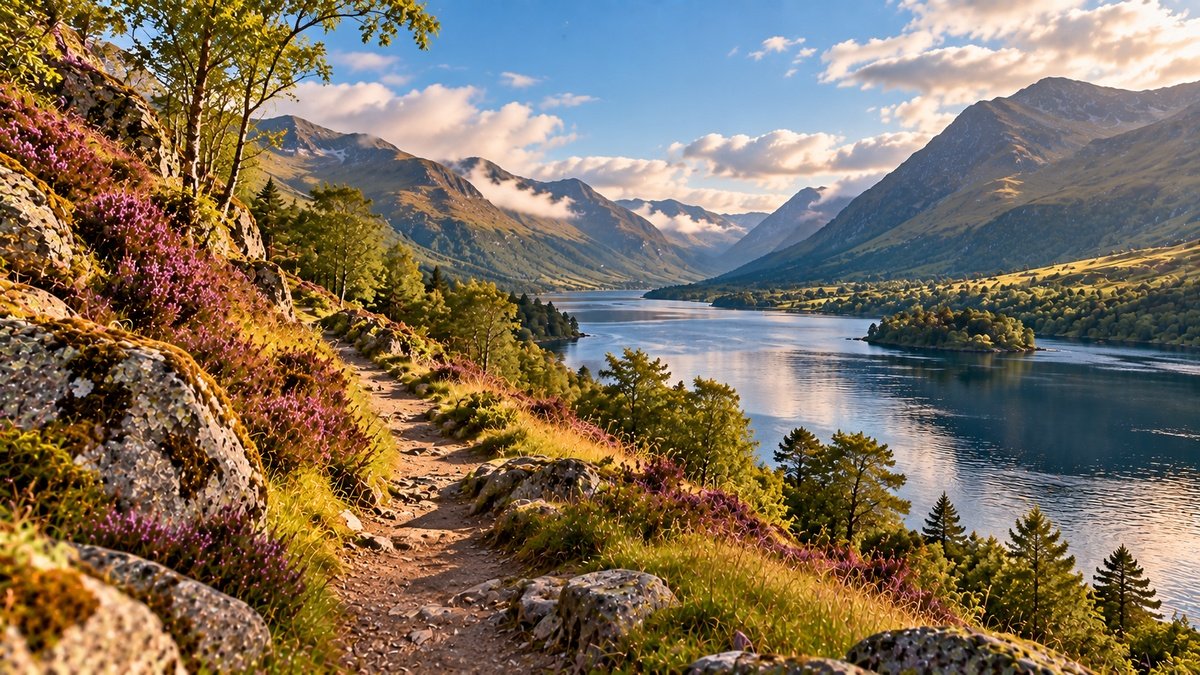
The Great Glen cuts a striking line through the Scottish Highlands. Stretching across the country from the area around Inverness and the Moray Firth towards Fort William and Loch Linnhe, it creates a natural corridor through mountains, lochs and valleys.
Today, we can travel through this landscape by road, path, boat or canal. We can look across Loch Ness, follow sections of the Caledonian Canal or watch mountains rise sharply from either side of the glen.
Yet the landscape existed long before any of those routes.
Beneath the water, woodland, roads and settlements lies a much older structure: the Great Glen Fault, a major fracture within the Earth’s crust whose history reaches back hundreds of millions of years.
Later, ice repeatedly moved through the Highlands and reshaped the valley. Water occupied deep basins. People travelled along the resulting corridor. Eventually, engineers connected natural lochs with constructed sections of canal.
The landscape we encounter now is therefore not the result of one event.
It is a landscape with many histories.
What Is the Great Glen?
The Great Glen is a long, remarkably linear valley that crosses the Highlands from north-east to south-west.
In geological terms, its position is closely associated with the Great Glen Fault, one of the most significant geological structures in Britain.
The glen also forms a striking topographical division within the Highlands. British Geological Survey descriptions identify the fault zone as separating the Northern Highlands from the Grampian Highlands.
For someone looking at a map, however, another feature may be more immediately noticeable.
Water.
A chain of freshwater lochs occupies much of the valley, including Loch Ness, Loch Oich and Loch Lochy. Together with rivers and constructed canal sections, these waters form part of the route of the Caledonian Canal.
That combination of fault, valley, ice-shaped basins and waterways makes the Great Glen a particularly clear example of how geological history can continue to influence the way people move through a landscape.
The Great Glen Fault: A Landscape With a Deep History
The geological story of the Great Glen reaches far beyond human history.
The British Geological Survey describes the Great Glen Fault as the largest fault structure in the United Kingdom. Its wider geological structure extends far beyond the visible valley that crosses the Highlands.
BGS research places the formation of the fault around 400 million years ago, during the later stages of the enormous mountain-building processes known as the Caledonian Orogeny.
At that time, continental plates were colliding and rocks across what is now Scotland were being compressed, deformed, uplifted and fractured.
The fault did not experience only one simple episode of movement. Geological evidence indicates a long and complex history, including substantial sideways movement and later periods of reactivation.
This matters because the Great Glen should not be imagined as a crack that suddenly opened and produced the landscape we see today.
The fault created a major zone of fractured and weakened rock.
Much later, erosion could work upon that geological structure.
The Great Glen Was Not Created by One Earthquake
The word fault can easily create the wrong mental picture.
We might imagine a single earthquake splitting Scotland apart and leaving a valley behind.
That is not an accurate description of how this landscape developed.
The Great Glen Fault has a complex geological history involving movement over immense spans of time. The rocks around the fault became fractured and disrupted, creating a zone that later erosion could exploit.
British Geological Survey research describes a fault zone containing crushed and altered rocks rather than a simple open fissure.
Consequently, the relationship between fault and landscape involves several processes.
Tectonic movement established the geological structure.
Erosion helped expose and deepen the valley.
Glaciers later transformed it further.
When Ice Reshaped the Great Glen
The fault may provide the underlying geological line, but ice played a major role in creating the form of the landscape we recognise today.
During repeated glacial periods, large masses of ice moved through the Highlands.
Glaciers do not simply sit on top of a landscape. Moving ice can erode rock, transport sediment and deepen existing valleys.
The Great Glen provided an established corridor through the mountains, and glaciers followed and further scoured this line of weakness.
BGS describes the modern Great Glen as a valley scoured by glaciers during the Ice Age. Evidence elsewhere across the Highlands similarly records repeated glaciation and deglaciation as major influences on the present topography.
Ice therefore did not begin with a blank landscape.
It worked upon a geological structure that was already extraordinarily old.
The result is a useful reminder that landscapes are often cumulative.
One process creates conditions that later processes continue to modify.
The Lochs of the Great Glen
Water now occupies some of the deepest parts of this ice-modified landscape.
Loch Ness is the most internationally familiar of the Great Glen lochs, but it is not alone.
Loch Oich and Loch Lochy continue the chain towards the south-west, while rivers and shorter bodies of water connect different sections of the valley.
The long shape of these lochs reflects the structure of the glen itself.
Seen from above, water appears to trace the landscape’s underlying direction.
Our earlier Journal article Where Land Meets Water: Lochs, Rivers and the Highland Landscape explored how water changes our experience of Highland places.
In the Great Glen, that relationship becomes especially visible.
The water is not simply positioned within the scenery.
Its location is connected to the geological history beneath it.
Loch Ness Is More Than Its Legend
For many people around the world, Loch Ness is encountered first through a story.
The Loch Ness Monster has become one of Scotland’s most recognisable pieces of modern folklore and tourism culture.
Folklore can become part of a place. Stories influence how landscapes are imagined, visited and remembered.
But the legend is only one layer of Loch Ness.
The loch also occupies a deep geological depression within the Great Glen. Its steep surrounding slopes, elongated form and substantial depth belong to the physical history of the valley.
Its waters interact constantly with weather and light. Settlements, roads, woodland, archaeological sites and human histories surround it.
Looking beyond the legend does not require dismissing the story.
It simply allows the place to become larger than its most famous narrative.
The Great Glen as a Route Through the Highlands
Geography influences movement.
Mountain ranges can make travel more difficult, while valleys can provide corridors through otherwise challenging terrain.
The Great Glen’s long north-east to south-west alignment has therefore mattered to people as well as to water and ice.
Over time, different forms of movement have followed or crossed this landscape.
Today, roads, walking routes, settlements and waterways make that relationship particularly visible.
People experience the glen in many ways. Someone may travel its length by boat. Another person may walk part of a trail, drive between communities, stop beside a loch, commute through the area or encounter the landscape from a window.
No single form of access provides a more authentic relationship with the Great Glen.
Place can be encountered at different speeds and from different positions.
The Caledonian Canal: Working With the Landscape
Human engineering added another layer to the Great Glen in the nineteenth century.
The Caledonian Canal created a navigable route across Scotland between the east and west coasts.
Importantly, engineers did not excavate a continuous artificial channel for the entire journey.
The route makes extensive use of the natural geography of the Great Glen, incorporating existing freshwater lochs and connecting them with constructed canal sections, locks and other infrastructure.
Scottish Canals describes the complete Caledonian Canal route as approximately 60 miles long. The constructed canal sections account for about 22 miles of that route.
Thomas Telford and William Jessop were central to its design and construction after an Act of Parliament authorised the project in 1803. The canal opened in 1822, although later engineering work was required to address structural problems.
The canal therefore represents more than an object placed into the landscape.
Its route depended on the landscape already being there.
From Geological Movement to Human Movement
There is an unusual continuity in the story of the Great Glen.
First came movement within the Earth’s crust.
Much later came moving ice.
Water occupied the resulting basins and flowed through the valley.
People then used the same broad corridor for travel, settlement and communication.
Finally, canal engineering formalised part of that route into a navigable waterway.
These forms of movement happened at radically different scales and should not be treated as equivalent processes.
Yet together they show how the physical form of a landscape can influence what becomes possible within it.
The Great Glen Does Not Look the Same Every Day
Deep geological history can make a landscape sound permanent.
Our immediate experience tells a different story.
Cloud can conceal the mountains. Mist can remove the opposite shore of a loch from view. Rain changes the surfaces of rock and vegetation. Wind moves water and trees. Snow can temporarily redraw the edges of the landscape.
Sunlight can reveal one slope while leaving another almost without detail.
The geological structure may be ancient, but the visible landscape remains changeable.
This connects the Great Glen directly with our exploration of Highland weather and Highland light.
The underlying valley persists.
What we see within it can change from hour to hour.
Seeing Deep Time in an Ordinary View
Geological time is difficult to imagine.
A human lifetime provides an intuitive scale for years and decades. Written history can help us think in centuries or millennia.
Hundreds of millions of years belong to a different order of time.
Yet the Great Glen allows some of that history to become visible.
Looking along the length of Loch Ness means looking along a landscape strongly influenced by a geological structure with origins hundreds of millions of years in the past.
The shape visible today also reflects much younger glacial processes.
Beside them sit roads, bridges, locks, buildings and boats that belong to comparatively recent human history.
Several timescales can therefore occupy a single view.
The Names Add Another Layer
Geology explains only part of a place.
People also name landscapes.
Our article More Than a Name: Gaelic Place Names and the Highland Landscape explored how names can preserve traces of language, physical geography and human history.
The Great Glen provides many opportunities to see those layers together.
Inverness is Inbhir Nis in Gaelic, a name associated with the mouth of the River Ness.
The river, in turn, connects Loch Ness with the Moray Firth.
Here, geology, water, language and settlement overlap.
None provides the complete story alone.
Landscape Is Not Static
It is tempting to think of mountains as permanent and human activity as temporary.
The difference is largely one of timescale.
Rock deforms. Faults move. Ice erodes. Rivers transport sediment. Slopes weather. Water levels change. Vegetation develops and retreats.
Human communities also alter landscapes through settlement, agriculture, transport, engineering and changing patterns of land use.
Not all of these processes happen at the same speed, and not all changes carry the same significance.
Still, the Great Glen demonstrates why a landscape is better understood as a continuing history than as a finished object.
You Do Not Need to Climb a Mountain to Experience the Great Glen
Highland landscapes are often represented through elevated viewpoints, long hikes and remote summits.
Those experiences are meaningful to many people, but they are not requirements for engaging with place.
The Great Glen can be encountered from settlements, accessible viewpoints, roads, canal paths, boats, visitor locations and the shores of its lochs.
Someone may spend hours walking through the landscape. Someone else may stop briefly beside the water. Another person may experience the glen primarily through a journey between communities.
Mobility, health, caring responsibilities, work, weather, transport, confidence, time and personal preference all influence how people encounter outdoor places.
None of these factors makes one person’s experience inherently less meaningful than another’s.
Attention does not depend on physical difficulty.
A Common Misunderstanding: The Great Glen Is Simply a Crack in Scotland
The striking straightness of the Great Glen can make this explanation appealing.
But it compresses hundreds of millions of years of geological history into one image.
The Great Glen Fault is a major zone of deformation with a complicated history of movement and reactivation.
The valley visible today also reflects prolonged erosion and powerful glacial modification.
The lochs occupy parts of that modified landscape, while rivers, sediment, weather, vegetation and human activity continue to influence what we see now.
The fault is fundamental to understanding the Great Glen.
It is not the entire story.
The Orenna Perspective — Place Has a Past
At Orenna, a landscape is not simply where we are. It is also the result of what happened there before us.
The Great Glen makes that idea unusually visible.
We can stand beside water and encounter several histories at once.
Beneath the view lies an ancient geological structure.
The shape of the valley carries evidence of ice.
The lochs occupy the resulting landscape.
Names preserve traces of language.
Roads and paths record movement.
The Caledonian Canal adds a layer of engineering and social history.
Weather and light continue changing what becomes visible from one moment to the next.
We do not need to understand every geological process before a landscape can matter to us.
But knowing something of what lies beneath the view can change what we notice.
A mountain becomes more than a shape on the horizon.
A loch becomes more than water.
A valley becomes more than the space between two slopes.
The Great Glen reminds us that place has depth — not only in the landscape, but also in time.
References & Further Reading
British Geological Survey. Scientists Gain Access to ‘Once in a Lifetime’ Core From Great Glen Fault. BGS research examining the structure, formation and geological history of the Great Glen Fault.
British Geological Survey. The Northern Highlands of Scotland: British Regional Geology. Geological description of the Northern Highlands, including the Great Glen Fault and the development of the linear depression.
British Geological Survey. The North-West Highlands. An introduction to Highland geology and the role of tectonic and glacial processes in shaping the landscape.
Scottish Canals. Caledonian Canal. Information about the 60-mile navigable route through the Great Glen.
Scottish Canals. Caledonian Canal: History and Heritage. Historical information on the surveying, construction, opening and later development of the canal.
The Orenna Journal explores yoga, well-being, philosophy and place from historical, evidence-informed and contemporary perspectives. Geological processes are complex and scientific interpretations continue to develop as new evidence becomes available. This article provides an introduction to the Great Glen rather than a comprehensive geological account.